

Massive Typhoon Bolaven slamming Okinawa, heads for Koreas
A massive typhoon began to make landfall Sunday over Okinawa, bringing winds more ferocious than even the typhoon - weary Japanese island has seen in decades.
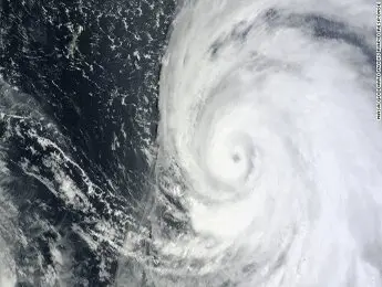
It will likely be the strongest since 1956, said CNN International meteorologist Tom Sater.
With a cloud field of ۲,۰۰۰ kilometers(۱,۲۵۰ miles), Typhoon Bolaven is ۲۰ times larger than Okinawa ' s length.
" It ' s been very, very severe, " said storm chaser James Reynolds, on the northwestern coast of the island.
Tree branches were flying through the air amid torrential rain, he said.
The infrastructure on Okinawa is designed to withstand violent storms. " Everything ' s made of solid concrete, " said Reynolds.
" Utility poles are so wide you couldn ' t even put your arms around them, " Reynolds said. " All the houses are built with concrete. There ' s no such thing as a beach house in Okinawa because it would just get destroyed by a typhoon. "
Still, the power was out where he was Sunday.
On Sunday evening, Bolaven was carrying sustained winds of ۲۱۳ kilometers(۱۳۲ miles) per hour, with gusts reaching ۲۵۹ kilomeers per hour(۱۶۱ mph) - - the highest since Typhoon Naha in ۱۹۵۶.
Bolaven was traveling northwest at ۱۵ kilometers per hour(۹ mph).
The storm is on course to hit China and the Korean peninsula.
It ' s " roughly the size of France to Poland in land mass, " said Sater.
" The typhoon is producing wave heights of ۱۶ meters high, so the possibility is there for a storm surge of ۸ to ۱۰ meters high on the coastline. Wind gusts will be strong enough to not only uproot or down trees and power lines, but could flip automobiles.
" Okinawa is ۱۰۰ kilometers(۶۲ miles) long. The size of Bolaven ' s eye is roughly ۳۰ kilometers(۱۹ miles) in width. This means many residents could experience the eye passing over them; unfortunately, that means putting up with the strongest winds the storm can produce, followed by a calm period with a brief clearing of the skies overhead, then another chaotic period of damaging winds that will be blowing in the opposite direction of the previous winds. "
Rainfall totals could top ۵۰۰ mm(۲۰ inches) in ۲۴ hours, said Sater.
Storm surges are expected to be a major problem for Okinawa. Highways on low - lying barrier islands could be completely washed out, with surges at the coast expected at about ۸ meters(۲۶ feet) high.
More than ۴۰۰,۰۰۰ people in the area live in elevations less than ۵۰ meters(۱۶۴ feet).
Some low - lying areas have been evacuated.
" The storm will continue with typhoon strength into the East China Sea, then into the Yellow Sea with its eyes on the Korean Peninsula, " Sater said.
Taiwan could be in for a pounding due to something called the Fujiwhara effect, he said.
Typhoon Tembin made landfall in southern Taiwan a few days ago, and was expected to work its way toward Hong Kong. But Bolaven, which is much stronger, has stopped Tembin ' s movement toward Hong Kong and has been spinning it around. Tembin is likely to make a second landfall in southern Taiwan.
"As Typhoon Bolaven moves northward towards the Yellow Sea, it will drag Tembin toward the China coast very near Shanghai," said Sater. "That's an amazing change in direction."